Upgrade to High-Speed Internet for only ₱1499/month!
Enjoy up to 100 Mbps fiber broadband, perfect for browsing, streaming, and gaming.
Visit Suniway.ph to learn
Already have Rappler+?
to listen to groundbreaking journalism.
This is AI generated summarization, which may have errors. For context, always refer to the full article.
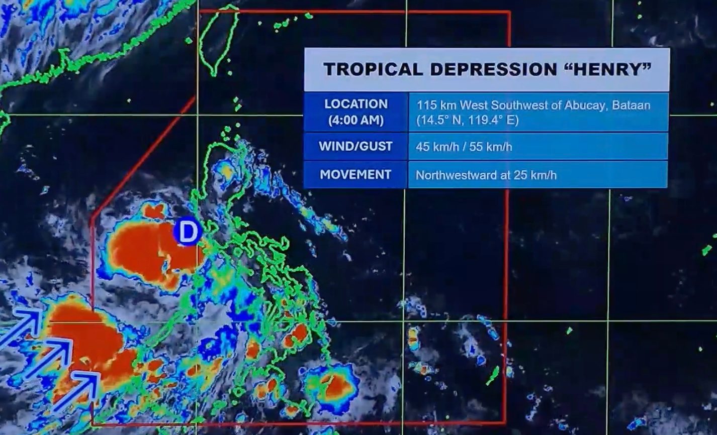
HENRY. Satellite image of Tropical Depression Henry as of July 1, 2026, 4 am.
PAGASA
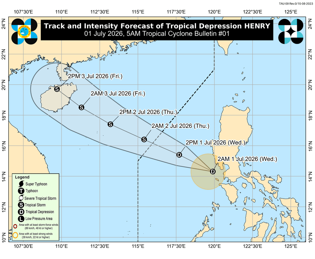
Tropical Depression Henry is the Philippines' eighth tropical cyclone for 2026, and the first for July
MANILA, Philippines – The low pressure area (LPA) inside the Philippine Area of Responsibility (PAR) developed into a tropical depression at 2 am on Wednesday, July 1.
It was given the local name Henry, as the country’s eighth tropical cyclone for 2026. It is also the first tropical cyclone for July.
The Philippine Atmospheric, Geophysical, and Astronomical Services Administration (PAGASA) said Henry was located 115 kilometers west southwest of Abucay, Bataan, as of 4 am on Wednesday.
The tropical depression is moving northwest or away from landmass at 25 kilometers per hour (km/h). It already crossed land on Tuesday, June 30, as an LPA.
So far, Henry has maximum sustained winds of 45 km/h and gustiness of up to 55 km/h. But PAGASA expects it to gradually intensify over the West Philippine Sea, and possibly strengthen into a tropical storm by Thursday morning, July 2 — also the time of its projected exit from PAR.
On Wednesday, Henry is bringing rain to Metro Manila, Calabarzon, Zambales, Bataan, Bulacan, Tarlac, Pampanga, Occidental Mindoro, Oriental Mindoro, and Marinduque. The most affected provinces could be Occidental Mindoro and Oriental Mindoro, where moderate to heavy rain (50-100 millimeters) is expected.
Henry is also enhancing the southwest monsoon or habagat, which is causing scattered rain and thunderstorms on Wednesday in the rest of Mimaropa, Western Visayas, the Negros Island Region, Central Visayas, the Zamboanga Peninsula, the Bangsamoro Autonomous Region in Muslim Mindanao, Lanao del Norte, Misamis Oriental, and Misamis Occidental. Palawan may be the most affected, with moderate to heavy rain (50-100 mm).
For strong winds due to Henry, Signal No. 1 was raised in the following areas in Luzon at 5 am on Wednesday:
- southwestern part of Zambales (San Antonio, Castillejos, Subic, Olongapo City)
- western part of Bataan (Morong, Bagac, Mariveles)
- Lubang Islands
PAGASA added that the periphery or outer bands of the tropical depression and the southwest monsoon are bringing strong to gale-force gusts to these areas:
Wednesday, July 1
- Batanes, Cagayan, Ilocos Norte, Pangasinan, Tarlac, Nueva Ecija, Pampanga, Bulacan, Metro Manila, Calabarzon, Occidental Mindoro, Palawan
Thursday, July 2
- Batanes, Cagayan, Pangasinan, Zambales, Bataan, Palawan
Friday, July 3
- Pangasinan, Zambales, Palawan
In the next 24 hours, up to moderate seas are likely in these seaboards:
- Seaboards of Cagayan and Isabela; western seaboards of Zambales, Bataan, and Lubang Islands – waves up to 2.5 meters high
- Seaboards of Aurora and Batanes; northern seaboard of Ilocos Norte; western seaboards of La Union, Pangasinan, and Palawan – waves up to 2 meters high
Small vessels should take precautionary measures, or avoid sailing, if possible.
PAGASA’s latest estimates show nine to 13 tropical cyclones could form within or enter PAR from July to December 2026. Here is the breakdown per month:
- July – 2 to 4
- August – 2 to 4
- September – 2 or 3
- October – 1 or 2
- November – 1 or 2
- December – 1 or 2
Formation inside or entry into PAR does not necessarily mean automatic impact on Philippine weather and sea conditions, as that would depend on multiple factors, including the location, track, and intensity of a tropical cyclone. – Rappler.com
How does this make you feel?
Loading