Upgrade to High-Speed Internet for only ₱1499/month!
Enjoy up to 100 Mbps fiber broadband, perfect for browsing, streaming, and gaming.
Visit Suniway.ph to learn
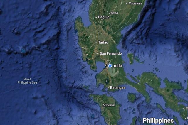
 Screen capture of the Philippines' satellite view in Google Maps as of April 2025 (Screengrab from Google Maps)
“Sa wakas.”
This was the sentiment shared by many Filipinos online after learning that Google Maps has finally recognized the waters west of the Philippine archipelago as the West Philippine Sea, replacing the previous South China Sea label.
For the longest time, the digital mapping platform marked the western portion of the archipelago’s waters as part of the South China Sea.
News organizations noticed the change on Monday, April 14, when the web mapping service began displaying “West Philippine Sea” instead of “South China Sea.”
“West Philippine Sea. Salamat, Google. Salamat, Pnoy,” journalist Raffy Tima said, referring to the late former president Benigno “Noynoy” Aquino III, who officially instituted the use of the term in 2012.
View this post on Instagram
A post shared by raffytima (@raffytima)
“Ayan, ‘di na nila masasabi na wala sa mapa,” another online user wrote with a laughing emoji.
“ABOUT TIME,” a different Pinoy commented.
“Thank you, Google!” exclaimed another X user with a heart-eyed emoji.
“AS IT SHOULD,” a different Filipino said.
“SA WAKASSSSSSSSS, PLEASE CONTINUE TO DO SOOO,” another X user wrote.
“Rightfully so! The West Philippine Sea is ours! #AtinAngWestPhilippineSea,” a different Pinoy said.
Another online user claimed to have noticed the label change on the platform even before it was reported by news outlets.
“Ohhh, I remember browsing around Maps for the last couple of weeks and I found this. Cool stuff!!” the X user wrote.
The West Philippine Sea refers to the maritime areas along the western side of the Philippine archipelago within the country’s 200-nautical-mile exclusive economic zone (EEZ).
The EEZ is sea zone where the coastal country has sovereign rights over the sea’s exploration and use of its marine resources. This is 200 nautical miles measured from the baselines of the territorial sea.
Based on a 2012 administrative order signed by Aquino, these are the Luzon Sea, “as well as the waters around, within and adjacent to the Kalayaan Island Group and Bajo de Masinloc, also known as Scarborough Shoal.”
In 2013, administration questioned the legality of China’s sweeping claims and activities in the South China Sea by initiating an arbitration under the 1982 United Nations Convention on the Law of the Sea (UNCLOS) dispute settlement procedures.
In 2016, the Permanent Court of Arbitration (PCA) under the United Nations ruled in favor of the Philippines, declaring that China’s nine-dash line claim over the disputed waters had no legal basis.
The international tribunal pointed out that there was no evidence Beijing had exercised exclusive control over the disputed waters or its resources.
The PCA also found that China violated the Philippines’ sovereign rights in its EEZ by interfering with Philippine fishing and petroleum exploration, constructing artificial islands, and failing to prevent Chinese fishermen from fishing in the zone.
The Philippines was the first country to challenge China’s expansive claims over the disputed waters.
Vietnam, Malaysia, Indonesia and Singapore also have overlapping claims in the South China Sea.

 1 month ago
19


